AAMI Park Melbourne
 (1 vote, 100.00% worth checking out)
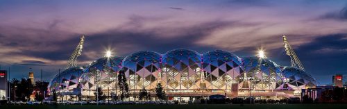
© mohamad atif mohamad nadzir
Location:
Edwin Flack Field
Olympic Boulevard
Melbourne
Victoria
Australia
coordinates: -37.8250389,144.9835510
open coordinates in google maps
open coordinates in apple map
Building names(s): AAMI Park Melbourne / Melbourne Rectangular Stadium
Architect/Designer: Cox Architects
architect website:
more images:
Completion date:
completion date: 2010
function(s): sports, stadium
credentials/awards: 2011 Victorian Architecture Medal, Awards, Victorian Architecture Medal
Construction cost: A$268 million
Capacity Total: 30,050
Super Rugby: 29,500
Field dimensions: 136 x 85m
getting there:
Tram
Tram 70 (Wattle Park) – Tram services from Flinders Street and Richmond Stations stop at Rod Laver Arena (Stop 7B), Hisense Arena (Stop 7C) and AAMI Park (Stop 7D).
Tram 48 (North Balwyn) & Tram 75 (Vermont South) – Stops adjacent to MCG on Wellington Parade.
Train
Richmond Station
> Lilydale, Belgrave, Alamein, Glen Waverley, Frankston & Cranbourne / Pakenham lines
Jolimont Station
> Epping & Hurstbridge
Flinders Street
> All lines
All of these stations are within walking distance of the Melbourne & Olympic Parks precinct. The addition of the Champions Walk and William Barak Bridge from Birrarung Marr makes short pleasurable walk from the City, Federation Square and along the Yarra.
Bus:
Bus 605 (City – Gardenvale)
Travels down Exhibition Street, Batman Avenue and Olympic Boulevard (previously known as Swan Street)
Bus 246 (Latrobe Uni – Elsternwick Station)
Travels down Punt Road, stops at the corner of Olympic Blvd.
From here patrons can walk approximately 500 metres to Hisense Arena, Rod Laver Arena and Olympic Park Stadium.